

By Frank Strait
Severe Weather Liaison
S.C. State Climate Office
S.C. Department of Natural Resources
Key Points:
-The Tropical Storm Helene has formed over the northwestern Caribbean Sea. It will rapidly intensify into a major hurricane as it tracks from the Caribbean Sea into and through the eastern Gulf of Mexico before landfall in Florida.
-Moving fast across the Florida Panhandle and Georgia, it will still pack a potent punch of damaging wind and flooding rainfall as its center passes just west of or over South Carolina later Thursday through early Friday.
-Damaging wind gusts over 50 mph will affect most of the state. There is a chance for gusts in the 60-70 mph range southwest of I-26. There may even be hurricane conditions in the far south over coastal Jasper, Beaufort, and Colleton Counties.
-Extreme rain over much of the Upstate will lead to potentially widespread flash flooding. There will also be moderate to perhaps major river flooding, despite drought conditions in this area.
The rest of the state will be at risk for isolated flash flooding; minor to moderate river flooding is possible in the wake of Helene.
Strong onshore winds will lead to elevated tide levels and coastal flooding along our coast. Lower astronomical tides help and should keep this from becoming an extreme coastal flooding event, but moderate to major coastal flooding is possible Thursday night.
Isolated tornadoes will be a risk later Thursday and Thursday night for nearly all of South Carolina as Helene’s center passes by to the west and possibly crosses the Upstate late Thursday night.
There remains some uncertainty in the forecast track and intensity; read below for details.
It’s increasingly looking like most South Carolinians will have a sleepless Thursday night. Tropical Storm Helene has formed over the western Caribbean Sea. Yes, Helene, the storm off our coast last week never became ‘tropical enough’ to be classified as a tropical or subtropical cyclone and never earned a name, so Helene is the name we’re using here.
Shown is the track and uncertainty cone graphic from 11 a.m.
This is the track and uncertainty graphic for Helene from Advisory 5, issued at 11 a.m. EDT Tuesday.
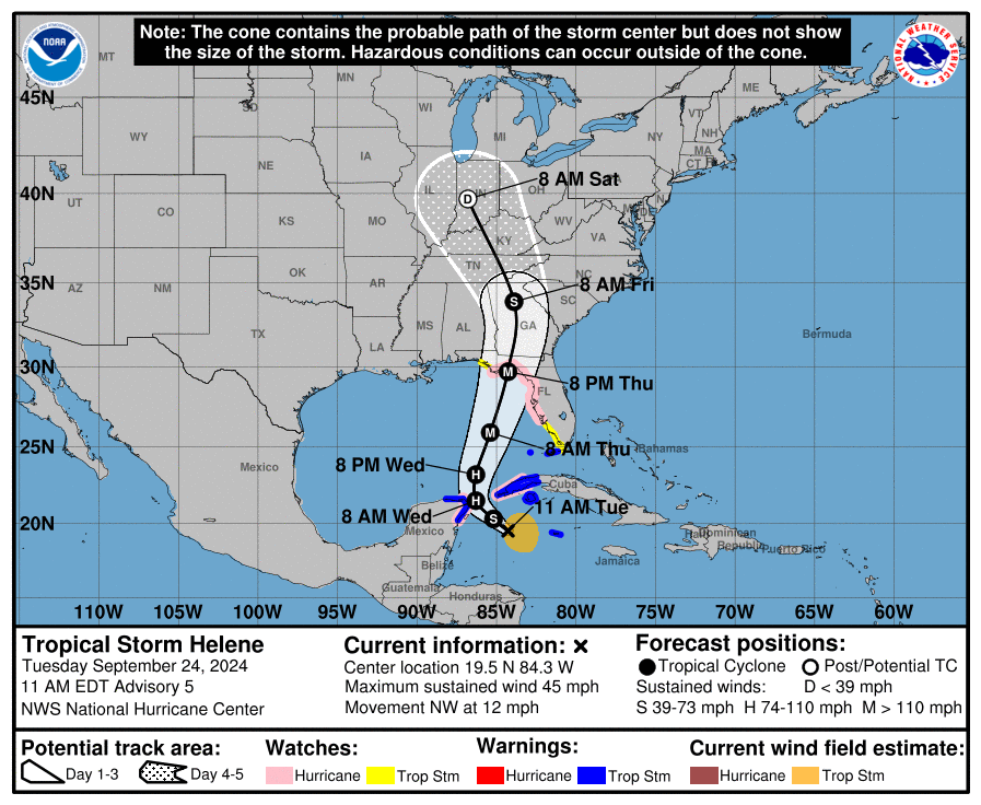
We don’t have any watches or warnings in effect for South Carolina yet, but those likely will be forthcoming soon. Remember that the cone only refers to the area where the storm’s center is most likely to track and that impacts from Helene will occur outside the cone. In this case, the impacts will affect areas far outside the
The primary concern I have right now about Helene is the strength of the winds we’re likely to see. Normally, when a hurricane hits the Gulf Coast of Florida and attacks us from the southwest, we see the storm weaken considerably before reaching us. Even major hurricanes down there usually don’t bring us widespread damaging wind. Helene may be one that does, for two reasons. First, Helene will be a much larger hurricane than average; the usual diameter of tropical storm force winds around a hurricane is about 300 miles, but with Helene, it will be closer to 400 miles. Bigger storms take longer to spin down. Second, Helene will be moving faster than most hurricanes; that also allows the strong winds to reach farther inland than usual.
I hope they’re wrong, but computer models have consistently shown wind gusts peaking at or above 50 mph over most of the state for days. Southern parts of the state are at even greater risk, with the potential for gusts of 60-70 mph for the Central Savannah River Area (CSRA) and Lowcountry, especially the coastal areas. So, Helene is increasingly looking like a strong tropical storm for us.
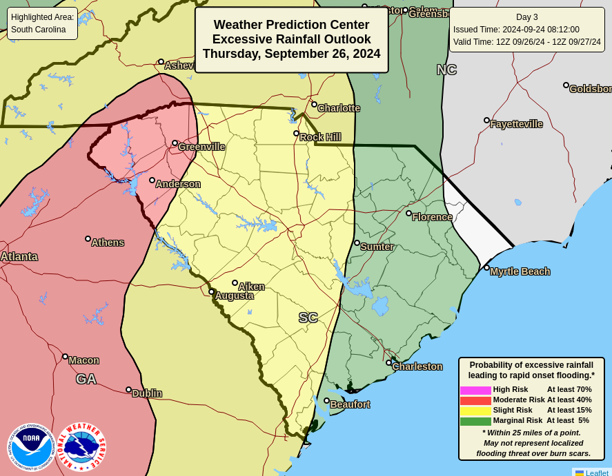
Heavy rainfall and flooding are also primary hazards for us. There is pretty good agreement among computer models for the Upstate to see 4-8 inches of rain over 12-18 hours from Helene. That area also will see locally heavy rain from a cold front moving in and becoming stationary ahead of Helene; that could be 1-3 inches. So, there is a significant flooding risk for the Upstate Thursday night into Friday, and the Weather Prediction Center has most of the region in a level 3 of 4 moderate risk area for flash flooding.
The Weather Prediction Center’s Excessive Rainfall Outlook for Thursday and Thursday night, indicating the risk for flash flooding across SC is shown above.
The Weather Prediction Center’s Excessive Rainfall Outlook for Thursday and Thursday night, indicating the risk for flash flooding across the Palmetto State.
The rainfall amounts will be less over the rest of the state and least toward the Grand Strand, but almost the entire state will be at some level of risk for at least isolated flash flooding, as even the Pee Dee region will be seeing 2-4 inches of rain.
With all this water landing in South Carolina and our river watersheds in North Carolina and Georgia, we will see river flooding, with moderate to possibly major river flooding in the Upstate, Midlands, and CSRA starting Friday.
Our coastal areas will get a storm surge from Helene of 1-3 feet. The severity of coastal flooding will depend on how well the worst of the surge lines up with high tide. Prolonged onshore winds will result in a long period of waters above the astronomical tide predictions, and it’s possible that we will see moderate to major coastal flooding should Thursday night’s high tide and the highest storm surge align perfectly. The highest surge will occur in the Lowcountry, where the strongest onshore winds will occur.
As is usual with a storm with the center going by to our west or with the center passing over the western part of the state, there will be a risk for isolated tornadoes later Thursday through early Friday. This risk will be greatest along our coast but will cover most of the state.
The uncertainty level is diminishing as Helene takes shape down in the Caribbean, but there remains some wiggle room in the forecast. However, there is only so much wiggle room and time is short. We’re only 48 hours or so from Helene’s effects beginning over South Carolina. You should be getting ready, and if you need help deciding how to prepare, SCEMD has the information you need at hurricane.sc.


