

From The South Carolina Climatology OFfice
By Frank Strait
Severe Weather Liaison
S.C. State Climate Office
S.C. Department of Natural Resources
TD 4 / Debby-To-Be Update
Key Points:
–Uncertainty remains high on the potential track and timing of TD 4/future Debby. However, it appears likely that at least parts of South Carolina will have major impacts from the storm.
–There is higher confidence in the risk of extreme rainfall over parts of the state. The amount of rain that falls and its timing will depend on the timing and track of the storm. This is also the case for where the heaviest rain will fall; while the Coastal Plain is at greatest risk, flooding rain may also occur elsewhere in the state.
–The confidence level is lower on the magnitude and timing of the wind risk. However, strong tropical storm-force (50 knots, 58 mph) winds or stronger appear likely over the coastal Lowcountry as early as Tuesday and may last for an extended period should the storm wander over the Atlantic. Hurricane-force winds are a reasonable worst-case scenario.
–Coastal flooding from storm surge and above-average astronomical tides will likely affect some or all our coast Tuesday through Thursday.
–Isolated tornadoes will likely be a concern for parts of the state Tuesday through Thursday.
Here’s an update on our tropical depression, centered close to Havana, Cuba as of early afternoon, though the center is still poorly defined. One of the bigger worries from yesterday was that it would be a slow mover as it crossed South Carolina, perhaps even wandering over us or nearby for a few days. This concern has increased today. This scenario will result in days of tropical rains that may lead to major flooding, drought notwithstanding.
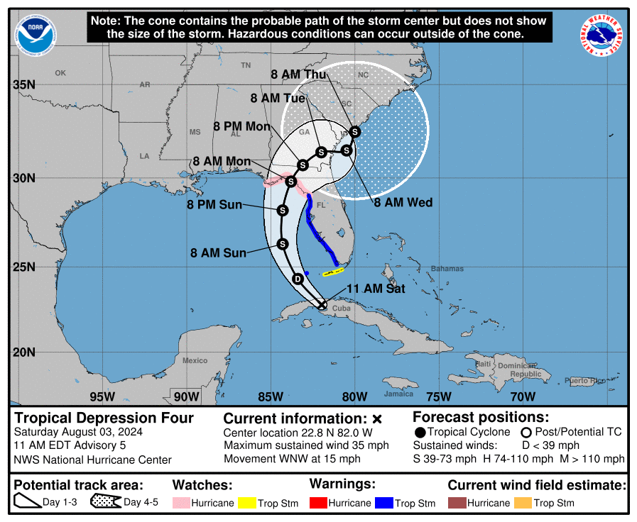
The National Hurricane Center’s (NHC) advisory graphic from this morning’s 11 a.m. advisory indicates that our depression, soon to be Tropical Storm Debby, will move across hot waters over the eastern Gulf of Mexico and into the Florida Nature Coast by Monday morning. After that, NHC calls for the storm to slow considerably, drifting into South Carolina by Thursday morning.
They point out in their discussion that there is considerable uncertainty about what will happen on Monday and beyond. Before that time, the only question is how strong the storm will get while moving over those steamy waters (as warm as 90°) along its forecast track. It could get stronger and there’s a chance it’s a hurricane upon landfall in Florida. On the other hand, its poor state of organization and less-than-ideal environment (there’s some dry air contamination) may slow its intensification.
So, the situation we face in South Carolina is uncertain in terms of the magnitude of wind, storm surge, and tornado risks with this storm. Those will depend on how intense the storm gets over the Gulf of Mexico and whether it can wander out over the Atlantic for a while and regain intensity. Waters off the Southeast Coast are also quite warm, even close to shore, with surface temperatures mostly at 84-88°. There is deep warm water in the Gulf Stream, too, which is only about 100 miles offshore. The risk for it to spend enough time over the Atlantic, and far enough offshore to strengthen into a hurricane, seemed like a long shot to me yesterday, but now it seems to have a 20-30% chance of happening, more than just a reasonable worst-case scenario.
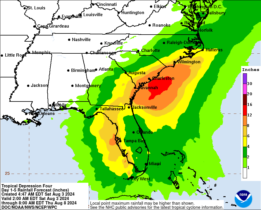
The thing that concerns me most right now is the risk of extreme rainfall over parts of the state, perhaps even much of the state over the next five to six days. Of course, our Coastal Plain will have the greatest risk, but the storm track is in question and excessive rainfall amounts may even reach the Upstate.
Part of the problem is that we have one of those ‘not as hot fronts’ that has pushed into the state and is becoming stationary today. That will give us locally heavy rainfall this weekend in advance of our tropical cyclone’s arrival.
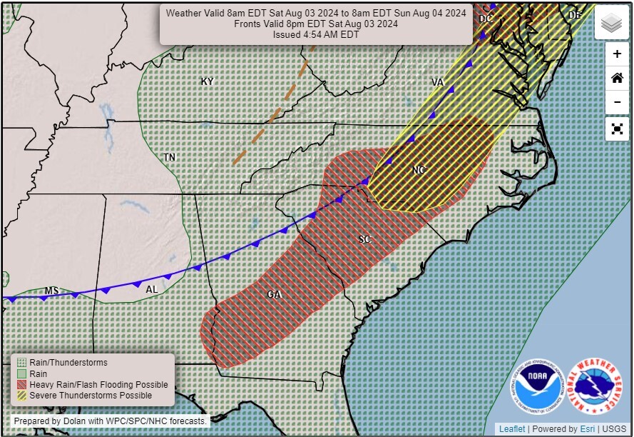
This morning’s weather map from the Weather Prediction Center, showing the position of a cold front over South Carolina and notable hazards for today and tonight.
Not only that, the weakening front will serve as a second focusing mechanism for heavy rainfall and thunderstorms as the tropical cyclone moves in from the south. The flow around the storm will pump thick humidity from the tropics into South Carolina and the lingering front, which will result in heavy rain even ahead of the tropical cyclone’s arrival. Then, we risk seeing extreme rains Tuesday through Thursday over parts of the state as TD4/Debby wanders through.
I’m loathed to throw extreme-looking computer model output at you because that tends to be the tactic of hypesters, social media-ologists, and click-baiters. However, rainfall totals for the next week from this morning’s computer models are downright scary. They’re indicating double-digit rainfall totals over much of our Coastal Plain. Let’s hope and pray that the models are overdone!
We’re still days away from the event and things could change but the trends right now are very ominous and the forecast is starting to look grim. So, you need to prepare for days of stormy weather ahead. Coastal residents should already be getting ready for the wind and storm surge risks. Coastal residents and inland residents should consider their risk for flooding and those in flood-prone areas should start considering what needs to be done to protect their family and property should the worst case come to pass. Everyone should have their tornado sheltering plans in place because that is a risk as well. Of course, if you need storm preparation advice, your best resource is hurricane.sc.
WEATHER UPDATE: Uncertainty Remains High For Tropical Depression Debby


