

By Frank Strait
Severe Weather Liaison
S.C. State Climate Office
Key Points:
-A complex weather pattern involving a storm becoming stationary over the Southeast and two tropical weather features results in high uncertainty in the forecast over the coming days. Unfortunately, there is low confidence in this potentially high-impact situation.
-A tropical wave currently over eastern Cuba and Haiti is likely to spawn a tropical cyclone over the Bahamas in the next 24-36 hours. The next name on this year’s list is Imelda.
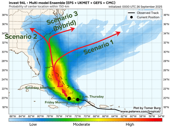
There are three possible scenarios for Imelda:
-First, Imelda takes a right turn due to interaction with Hurricane Humberto to its east, which takes it out to sea, so Imelda has little impact on South Carolina.
-Second, Humberto may be too far away to significantly affect Imelda’s track, allowing the storm over the Southeast to pull Imelda into South Carolina or North Carolina. Imelda could be a hurricane when it reaches South Carolina under this scenario, and its impacts could extend far inland.
-Third, there could be an ‘in-between’ scenario, where Imelda reaches our coastal areas before turning to the east under the influence of Humberto. That would result in only coastal areas being impacted. However, the impacts may be prolonged because there is a chance that Imelda would be slow-moving or even stationary for a day or so under this scenario.
-We have a ‘prepare for the worst, hope for the best’ situation. Plan to spend the weekend preparing for a potential hurricane impact early next week if you live along our Coastal Plain. Those further inland should monitor the situation and have general disaster preparations in place.
As of this morning, not much has changed with our threat from the tropical feature we’re calling Invest Area AL94. It remains a generally disorganized tropical wave over Haiti and eastern Cuba.
Meanwhile, Humberto is strengthening to the northeast of the Leeward Islands. It became a hurricane this morning, and the National Hurricane Center forecasts it to intensify into a Category 3 hurricane by Saturday afternoon, then peak as a Category 4 hurricane on Sunday into Monday.
Yes, that’s Gabrielle in the northeast corner of the loop above. It’s no longer a tropical entity and is headed to Europe. There’s also a tropical wave near 30° west that’s generating thunderstorms, but that’s not a concern for us for now.
We continue to see three possible scenarios with AL94 (some say 94L), which the graphic will help to illustrate better.
We expect to see AL94 move into the southern Bahamas, where low pressure is likely to form and quickly become a tropical storm named Imelda. Waters are very warm and warm to significant depths around the Bahamas, so it should strengthen steadily, and it might be a hurricane before it leaves the Bahamas early Monday or shortly thereafter.
Things become very uncertain after that due to the complexity of the weather pattern we’re heading into. Humberto to the east will likely become a major hurricane, which may impose its will on strengthening Imelda and cause it to turn east out to sea. That’s Scenario 1, and it’s what we hope will happen, because it would result in little to no impact in South Carolina, other than rough surf, rip currents, and hazardous coastal waters. We’ll be dealing with that anyway, thanks to Humberto.
The second scenario is one where Humberto tracks too far away to have much of an effect on Imelda. That would allow Imelda to keep tracking northward and into the Carolinas. There’s a good chance it will be a hurricane when it arrives if this scenario plays out, although questions would remain about its track and where the worst of the storm would hit. Some computer models that simulate this scenario have us getting nailed with a hurricane, while a few predict the worst impacts will be felt in North Carolina. A track into South Carolina would allow inland areas to experience serious wind and rain impacts — not Helene-level or Hugo-level impacts, but there would be a risk of locally damaging wind and flooding rain.
The third scenario is a hybrid between the two. In this case, Imelda would move into our coastal waters or just inland before making its turn. We’d see strong tropical storm or hurricane conditions along much of our coast, but most areas well inland would be spared severe impacts. However, the risk with this scenario is that Imelda would get caught between steering influences: one being the storm system now over the Southeast, which will slowly drift northeastward in the coming days, and the other being Humberto. Those two may play tug-of-war over Imelda for a day or two, causing Imelda to sit and spin over or near our coastline.
That would really stink! We’ve seen what slow-moving tropical cyclones can do a few times over the last 10 years or so (Florence and Debby come to mind). If this scenario becomes reality, then some of our Coastal Plain would experience an extreme heavy rain event, a prolonged period (possibly 24-36 hours, hopefully not longer) of damaging winds, and a long-lasting storm surge over multiple high tide cycles.
At least the astronomical tides will be relatively low early next week, with the moon in its first-quarter phase. That’s a small help, should this storm impact us.
So what do you do right now? If you’re along our coast, your mindset should be that there is a strong chance for a hurricane to affect you early next week, and the worst-case scenario is that it could be a prolonged event. You’ll have to prepare accordingly, even though there’s a chance that we dodge the bullet this time. It’s better to be ready for no storm than to be unprepared for a hurricane. Further inland, ensure your general disaster preparations are in place and that you can cope with prolonged power outages should the storm directly impact our state.
The uncertainty persists into the late-week period, but there is hope that a strong area of high pressure will build into New England toward the end of next week, serving to push the storminess away to the east.
Storm preparation is a chore, but we should be pros at it by now. If you aren’t a pro yet or one of our state’s newcomers, you can visit hurricane.sc to get storm prep advice and evacuation zone information.


